|
To swimmers and surfers, the ocean is an aquatic playground. However, to witnesses of a destructive tsunami wave, the ocean can also be a source of potential danger to lives and property.
Waves, tides and currents are what drive the sea. Waves we associate with the beach and having fun. Tides signal the stages of the moon and the time of day. Currents provide passage for international boats that bring us food and goods from far away lands. All three contain energy of motion and potential energy. The slightest change in any of these effects us in many more ways than you think.
WAVES
Everyone has seen waves on a lake or oceans. But what are they? Waves are actually energy. Energy, not water, moves across the ocean's surface. Water particiles only travel in a small circle as a wave passes.
 Tsunamis, often erroneously called tidal waves, result when underwater earthquakes and volcanic eruptions disrupt the water's surface. Most other waves are caused by wind driving against water. When a breeze of two knots or less blows over calm water, small ripples form and grow as the wind speed increases until whitecaps, comprised of millions of tiny air bubbles, appear in the breaking waves. Waves may travel thousands of miles before rolling ashore and dissolving as surf. Tsunamis, often erroneously called tidal waves, result when underwater earthquakes and volcanic eruptions disrupt the water's surface. Most other waves are caused by wind driving against water. When a breeze of two knots or less blows over calm water, small ripples form and grow as the wind speed increases until whitecaps, comprised of millions of tiny air bubbles, appear in the breaking waves. Waves may travel thousands of miles before rolling ashore and dissolving as surf.
A wave's size and shape reveals its origins. A steep, choppy wave out at sea is fairly young and was probably formed by a local storm. Slow, steady waves near shore which rear high crests, and plunge into foam come from far away, possibly another hemisphere.
No two waves are identical, but they all share common traits. Every wave, from a tiny ripple to a huge tsunami, has a measurable wave height, the vertical distance from its crest (high point) to its trough (low point). Wind speed, duration, and fetch (the distance it blows over open water) determine how high a wave grows. The maximum height in feet is usually one half or less the wind speed in miles per hour. Wave height decreases gradually as the wind dies and the wave approaches shore. When it touches bottom, it slows, the back overtakes the front, forcing it into a peak, curves forward, and dissolves into a tumbling rush of foam and water called a breaker.
 Spilling breakers, a favorite with surfers, are turbulent water with foam cascading down the front. They form on gently sloping or flat shores and roll great distances before breaking. Spilling breakers, a favorite with surfers, are turbulent water with foam cascading down the front. They form on gently sloping or flat shores and roll great distances before breaking.
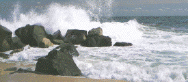
Plunging breakers form when the bottom rises abruptly toward the shore. As the crest folds over, it creates a large air pocket, followed by a smooth splash-up. Experienced surfers can sometimes crouch under the falling crest and lock themselves inside the air tube. However, plungers can hurl 135 pound boulders more than 100 feet in the air and can damage buildings 100 - 300 feet above the sea surface.
Waves are fun on a hot summer's day, but they are also a constant reminder of the sea's awe-inspiring power.
How are waves energy?
The best way to understand waves as energy is to think of a long rope laid on the ground. If you pick up one end and give it a good snap --there's a ripple effect all the way to the other end -- just like the waves on the ocean! That means that energy is applied at one end and it moves to the other end. The energy is released at the other end of the rope, just as the energy of waves is releases on shores.
What provides the energy?
In the case of ocean waves, wind provides the energy. Wind causes waves that travel in the ocean. The energy is released on shorelines.
What determines the size of the wave?
The size of a wave depends on:
- the distance the wind blows (over open water) which is known as the "fetch",
- the length of time the wind blows, and
- the speed of the wind.
The greater these three, the larger the wave.
Where are the largest waves found?
The largest waves are found in the open ocean. Waves continue to get larger as they move and absorb energy from the wind. When the wave height becomes one seventh the size of the wave length, the wave will fall over, making white caps. As they get closer and closer to shore, most big waves have broken down in size and speed.
 Wave Parts Wave Parts
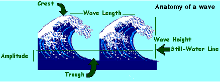
The crest is the highest part of the wave and the trough is the lowest. The distance between the crest and the trough is the wave height. The distance from crest to crest is the wave length. The period of a wave is the time it takes for each crest to pass a certain point.
- STILL-WATER LINE - The level of the ocean if it were flat without any waves.
- CREST - The highest part of the wave above the still-water line.
- TROUGH - The lowest part of the wave below the still-water line.
- WAVE HEIGHT - The vertical distance between the crest and the trough.
- WAVE LENGHTH - The horizontal distance between each crest or each trough.
- WAVE PERIOD - The time it takes for two successive waves to pass a particular point. For example, it you are standing on a pier and start a stopwatch as the crest of a wave passes and then stop the stopwatch as the crest of the next wave passes, you have measured the wave period.
- WAVE FREQUENCY - The number of waves that pass a particular point in a given time period.
- APMLITUDE - The amplitude is equal to one-half the wave height or the distance from either the crest or the trough to the still-water line.
TIDES
The Effect Of The Sun And Moon On Tides
All surfaces of Earth are pulled toward the moon and the sun. The oceans, which are liquid, are greatly affected by two forces of nature:
- the gravitational pull of the sun and moon, and
- the centrifugal forces the earth applies as it spins.
Since the moon is four hundred times closer to Earth, it has more influence on tides than does the sun.
 What does the pull of the sun and moon do to the oceans? What does the pull of the sun and moon do to the oceans?
It creates two types of tides, high and low! As the moon rotates around Earth, tidal bulges occur. The bulge is really a large wave beneath the moon that moves across the earth. On the opposite side of Earth, there is a second bulge. These bulges are high tides. Between each high tide, there is a low tide. There are usually 2 high and 2 low tides occur each 24 hours and 50 minutes, because that is how long it takes the moon to rotate around Earth.
Where Does Water Go At Low Tide?
Sea water does not follow the moon or go to the middle of the ocean, it stays in the same place. Think of a coin sitting on a table. Imagine a magnet periodically passing over this coin. The magnet is not close enough to catch the coin, but instead makes an edge of the coin rise a few centimeters. This is similar to what the moon does to the ocean. Like the coin, the ocean rises periodically because it is attracted to a force above it (the moon or the magnet). Neither the water in the ocean or the coin move or follow the above force, they just occasionally react to it.
 Spring Tides And Neap Tides Spring Tides And Neap Tides
When the moon is full or new, the gravitational pull of the moon and sun are combined. At these times, the high tides are very high and the low tides are very low. This is known as a spring high tide. During the moon's quarter phases the sun and moon work at right angles, causing the bulges to cancel each other. The result is a smaller difference between high and low tides and is known as a neap tide.
Tides Around The World
Tidal changes are different in various parts of the world. Near the equator, there is very little noticeable change because a large volume of water is spread out over a wide range. The highest tides in the world are at the Bay of Fundy in Nova Scotia. The bay is very narrow, so water rushing in from the ocean can rise and fall up to 20 meters a day.
CURRENTS
Just like waves, oceans currents are always moving about.
Doesn't the wind cause ocean currents?
Winds affect the ocean's surface only. The winds that most affect the oceans' currents are:
- The Westerlies (40-50 degree latitudes) blow west to east.
- The Trade Winds (20 degree latitudes) blow east to west
 Both winds are a result of warm air from the tropics moving to the poles and incorporating the rotation of Earth into their movement. In the Northern Hemisphere, they move clockwise. In the Southern Hemisphere, they move counter-clockwise. Both winds are a result of warm air from the tropics moving to the poles and incorporating the rotation of Earth into their movement. In the Northern Hemisphere, they move clockwise. In the Southern Hemisphere, they move counter-clockwise.
Doesn't temperature cause currents, too?
Yes. Differences in temperature between the cold waters of the poles and the warm waters near the equator cause currents. Cold-water currents occur as the cold water at the poles sinks and slowly moves toward the equator. Warm-water currents travel out from the equator along the surface, flowing toward the poles to replace the sinking cold water.
The mixing and warming of water cause the currents. As these currents move around the world, they also help replenish the oxygen in the water.
What else causes currents?
Currents are also caused by tides, rain, runoff and ocean bottom topography. Topography is the surface features of a place. Ocean topography includes slopes, ridges, valleys and mountains! All these things are found at the bottom of the ocean, and can influence currents.
What is the Gulf Stream?
The Gulf Stream is one of the strongest currents known. It moves along through the Gulf of Mexico, past the east coast of the United States and on to Northern Europe. Without the warm Gulf Stream, England and other places in Europe would be as cold as Canada.
|
